Client: Jenny Yolo, I Spy DIY
Location: Milwaukee, Wisconsin
This map was commissioned by Jenny Yolo of I Spy DIY, to commemorate her favorite local antique shops in Milwaukee, including her very own Yolo Home, which opened in 2024 on National Avenue.
As she writes in her blog post about the map, “My goal was to create a map that’s both functional and beautiful, something you could hang on its own or as part of a gallery wall, truly celebrating Milwaukee and supporting the small businesses that make this city so special. I can’t wait to see how you frame and display it in your home. Thank you, Aly, for bringing this vision to life.”
It was a gift to work on my friend and neighbor Jenny Yolo on this piece, and to see it cherished by fellow antique lovers and interior decorators across my city has been the cherry on top! The photos below are by Jenny Yolo.
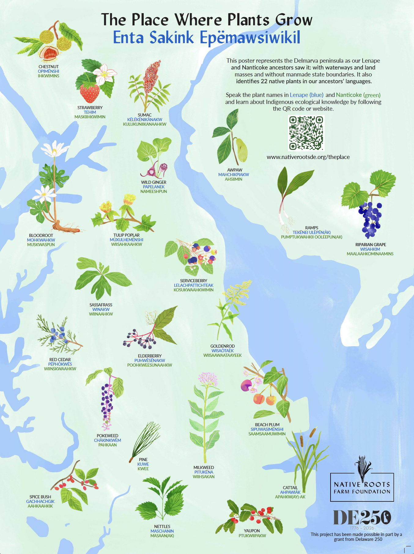
Map location: Delmarva Peninsula, Delaware, Pennsylvania and New Jersey
Art Director: Native Roots Farm Foundation
Description: This project was commissioned by Native Roots Farm Foundation and The Nanticoke Language Project.
Aly Miller created botanical illustrations of native plants, featuring their notable characteristics – including flowers, fruits, and leaves. How fun to include different seasonal aspects of the plants, all at once! Aly situated these twenty two illustrations on the Delmarva peninsula, in places representative of where they grow. The basemap features waterways and land masses, without manmade state boundaries.
NRFF created a multi-media resource that includes audio recordings for each plant in Nanticoke and Lenape - to allow listeners to immerse themselves in the beauty and subtleties of each of these languages. The plant profiles also highlight the diverse relationships Indigenous people have with the 22 select native plants.
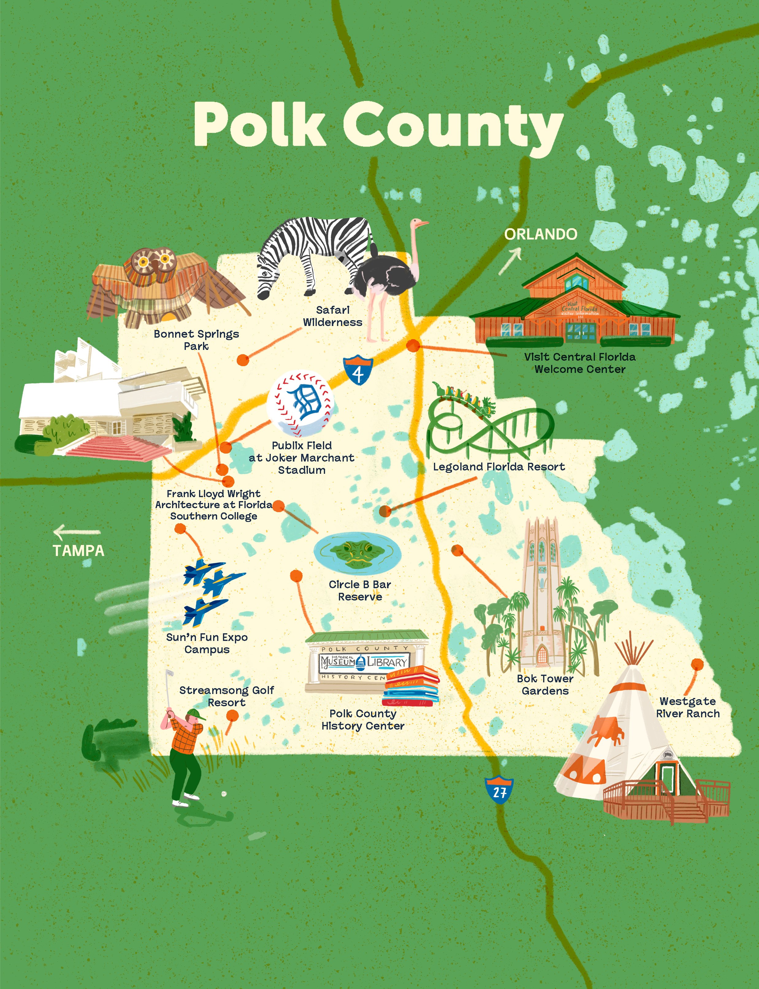
Client: Atlanta Magazine Custom Media
Location: Polk County, Florida
Art Director: Tara McCarthy
This illustrated map of Polk County, Florida was commissioned by Atlanta Magazine Custom Media for their Visit Central Florida Guide. It includes hand drawn spot illustrations of destinations like Bok Tower Gardens, Westgate River Ranch, Frank Lloyd Wright architecture at Florida Southern College, Streamsong Golf Resort, Publix Field, and Legoland Florida Resort. I enjoyed implementing their bold color palette and strategizing the layers of lakes, roadways and nature that make this area so unique.
I created this map for The Wall Street Journal, highlighting three roadtrips across the USA, from the Santa Monica Pier to Washington, DC. This illustrated roadtrip map shows Civil Rights landmarks, unique museums and quirky roadside attractions.
Client: The Wall Street Journal
Art Director: Marlene Szczesny
Location: New York, NY
This illustration was created in Adobe Photoshop by Aly Miller, using raster brushes, handmade textures and hand drawn scenes. AI was not used in the creation of this illustration.
Client: Women’s Wear Daily
Location: Paris, France
WWD Weekend commissioned me to design and illustrate a map of Paris, focusing on the beauty brands that surround the Jardin du Palais-Royal. I selected various skincare and haircare products that each brand is known for, and illustrated them into the map. Selected brands include Coelho Tres Confidential Le Salon, La Bonne Brosse, Kure Bazaar Paris, Sophie Carbonari, Serge Lutens, Les Parfums de Rosine, and Augustinus Bader.
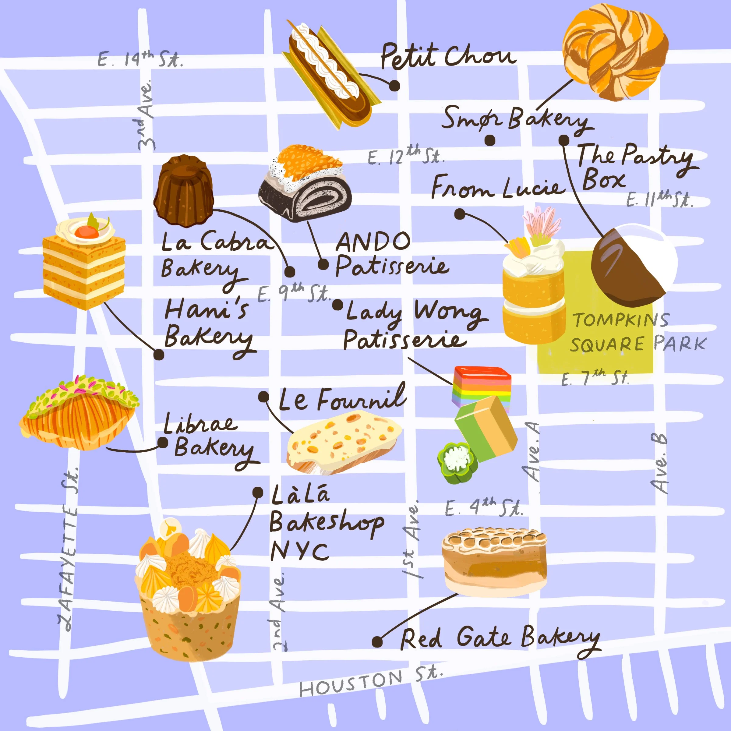
Map Location: East Village, NYC
Client: Wall Street Journal
Art Director: Marlene Szezesny
Description: This map was commissioned by the Wall Street Journal in January 2025 to depict the best pastry shops in the East Village for Charlotte Druckman’s article, “Ultimate Pastry Crawl: The New York Bakeries to Visit Now.” It was published on January 17, 2025 on the cover of the Off Duty section of the Wall Street Journal, and an image of the map was featured on the front page of the section.
This map features 12 colorful illustrations of pastries that you can enjoy in the East Village of NYC, which Druckman writes is experiencing a “pastry renaissance.”
The map features a pistachio croissant, a Swedish morning bun, black and white cookies , Vietnamese desserts and more.
This map was created in Procreate and Adobe Photoshop by Aly Miller, using digital brushes. AI was not used in the creation of this illustration.
Client: Atlanta Magazine
Location: Cobb Chamber, Georgia
Art Director: Sarah Carpenter,
Atlanta Magazine commissioned Aly Miller to create an illustrated map for the Cobb Chamber Business Guide published by Atlanta Magazine Custom Media.
The map features key cities and landmarks found within the county, including Marietta, Georgia'; Smyrna, Georgia; Ackworth Georgia; Kennesaw Georgia; and nearby Atlanta. Aly Miller illustrated 12 cultural and nature destinations ranging fro Lake Allatoona to the Smith Gilbert Gardens, Kennesaw State, the Strand Theater, Truist Park and the Battery Atlanta, Six Flags Over Georgia and more. She enjoys including local animals, plants, flowers and trees to fill out the map, adding extra-local flavor and meaning to each piece.
Client: Milwaukee Magazine
Location: Milwaukee, Wisconsin
This map was commissioned by the Milwaukee Magazine for an article called 7 Stops to Make While Biking the Beerline Trail. It includes illustrations of local businesses and parks along a popular bike path that sits on one of Milwaukee’s historic brewery railroads.
This is an illustrated map of the Clinton Hill neighborhood in Brooklyn, featuring local cafes, food and art destinations in the area. It was featured in They Draw and the book They Draw and Travel: 100 Illustrated Maps of Very Special Places (TDAT Illustrated Maps from Around the World) , published in 2020. You can also purchase an updated print of this map from my online shop.
Clinton Hill is a treelined Brooklyn neighborhood where artists, writers, makers, students and creatives have lived throughout history, and continue to make their marks today. Spaces for creating, thinking, and collaborating dot the map, creating an atmosphere that's ever-evolving against a backdrop of historic brick row houses and brownstones.
My map depicts the many cafes and community spaces that celebrate the arts, and even a few places that do both (like the women-run Relationships cafe and Playground Coffee Shop). There's imaginative spaces where you can sip coffee surrounded by modern art, places that imagine a more intentionally-designed food system, shops with vintage clothing and furniture, destinations for modern art and music, and even a few historic (maybe unofficial) arts landmarks. It's a special place that has fueled my creativity for years, and I hope you'll find some inspiration here, too
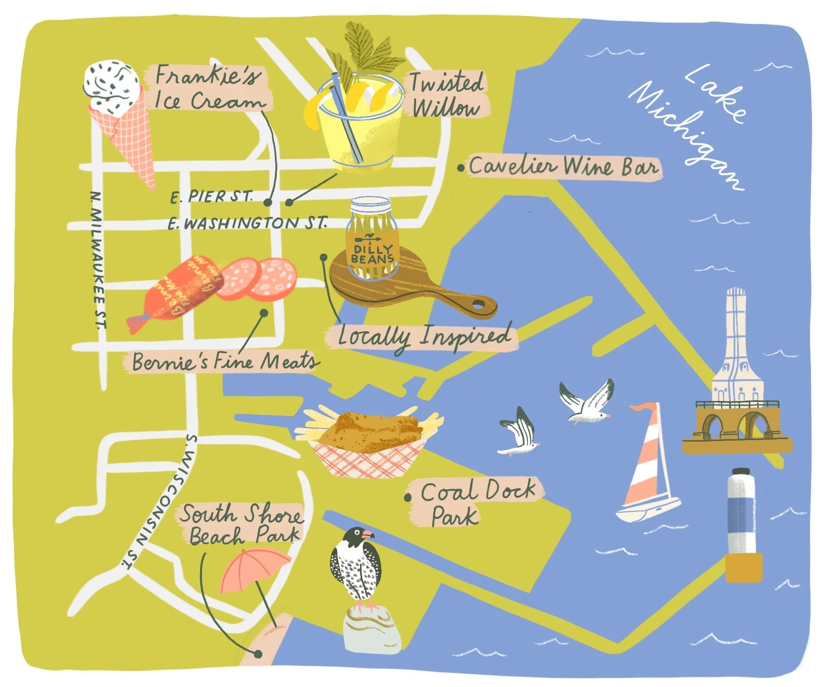
This illustrated map was commissioned by the Milwaukee Magazine to highlight the fun summer destination of Port Washington, Wisconsin. It includes illustrations of local eateries, parks, and places of interest along this historic shoreline town on Lake Michigan. This illustration was featured in the July 2024 issue of Milwaukee Magazine.
Client: Milwaukee Magazine
Art Director: Susan Evenson
Location: Milwaukee, WI
This illustration was created in Adobe Photoshop by Aly Miller, using raster brushes, handmade textures and hand drawn scenes. AI was not used in the creation of this illustration.
This map was commissioned by Women’s Wear Daily to accompany a story about how to spend a day in Mar Vista, focusing on locations close to the Santa Monica Airport. This map features spot illustrations to highlight local Mar Vista restaurants and shopping destinations along Venice Boulevard.
I was commissioned to illustrate this map of Philadelphia by Creative Director Brooke Forry for the Augustinians Province of St. Thomas of Villanova in Philadelphia. It tells the story of the Augustinian Church in Philly, complete with illustrations of each church, and spot illustrations that depict certain aspects of each community.
The Wall Street Journal commissioned me to illustrate this map of Nova Scotia for a story called Forget the Hamptons. Why In-the-Know Travelers Are Road-Tripping in Nova Scotia, depicting 4 road trip routes along its varied coastline. We worked together to create an interactive map at WSJ.com that users can scroll through to learn about each route separately.
This illustrated map of Lake Geneva, Wisconsin was commissioned by the Milwaukee Magazine to highlight the food, history, and architectural gems of downtown Lake Geneva. This map was featured in the April 2024 issue of the Milwaukee Magazine.
Client: Milwaukee Magazine
Art Director: Susan Evenson
Location: Milwaukee, WI
This illustration was created in Adobe Photoshop by Aly Miller, using raster brushes, handmade textures and hand drawn scenes. AI was not used in the creation of this illustration.
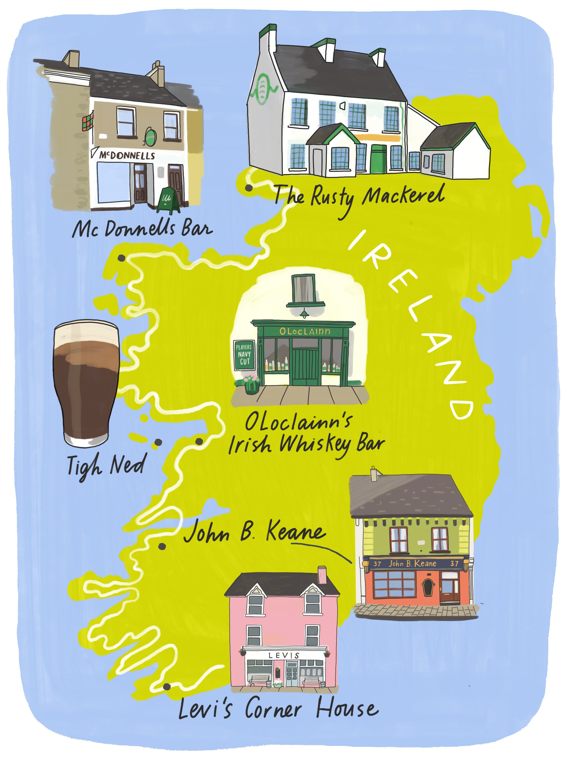
I was commissioned by the Wall Street Journal to create this map for an article called "Looking for a Real Irish Pub? Take This Roadtrip Down Ireland's Wild Atlantic Way" by Vic O'Sullivan. I enjoyed working on the architectural details of these pub illustrations, and coming up with a vibrant color scheme that suited the map.
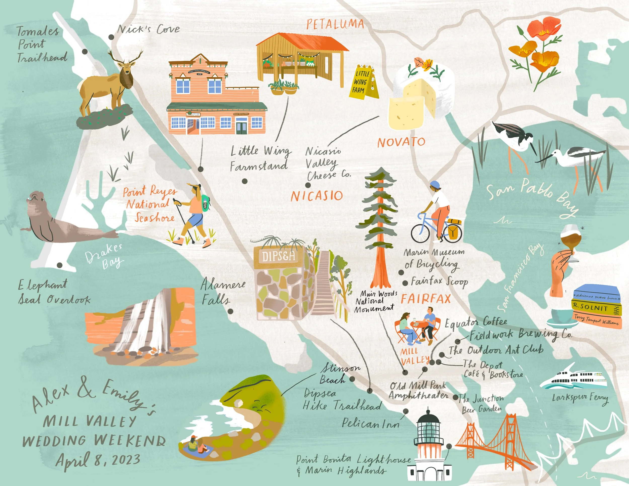
This map was commissioned for a wedding that took place in Mill Valley in the Bay Area. I worked with the lovely couple to create a poppy illustration for wedding announcements and printed materials, and a map that featured dozens of illustrations for local attractions and special places in the couple’s story. The couple utelized the individual illustrations for table cards and other printed materials.
For this map, I brought in some special hand painted textures, and local flowers and birds. Below I’m standing with a different color scheme that I created. In my opinion, both are winners!
I created this illustrated map of Paris for The Wall Street Journal, capturing the city's timeless beauty and iconic landmarks on each side of the Siene. My assignment was to create a map that highlights both sides of the Siene River, for a story called Which Side of the Siene is Best? published in winter 2024. Created digitally for print.
This illustrated map was commissioned by Joe Coffee Company, a specialty coffee company and cafe in New York City, for their 20th anniversary in 2023. Now with over 20 locations, Joe Coffee wanted a map that captured the energy of the city with special nods to their locations throughout the boroughs. In addition to this map, Aly created a library of illustrations to use throughout their merchandise like beanies, tote bags, tumblers, and even their cafe storefront in Park Slope, Brooklyn.
Client: Joe Coffee Company
Art Director: Ned Semoff
Location: New York, NY
This illustration was created in Adobe Photoshop by Aly Miller, using raster brushes, homemade textures and hand drawn scenes. AI was not used in the creation of this illustration.
I created this illustrated map of the Columbia River Gorge in the Pacific Northwest for the Wall Street Journal, Off Duty, October 2021. “A Fall Getaway in the Pacific Northwest—Easy and Gorgeous”
I illustrated this map of Pleasant Hill, CA and the surrounding Bay Area for Deanne O’Connor Creative Studio.
This illustrated press piece is an infographic, commissioned by author Albert Read, to tell the story of his book The Imagination Muscle published by Hachette UK, 2023. I then formatted the press piece into 2 social media slides. The book tells the story of the imagination, and how to strengthen it, with ideas proposed by writers and thinkers throughout history.
This illustrated map of a roadtrip between Nashville and New Orleans was commissioned for the Wall Street Journal for a story called “A Deliciously Diverting Roadtrip Through the Deep South” by Andrew Nelson. This illustrated shows destinations like Centennial Park in Nashville, the Natchez Trace, Tupelo Hardware, historic Oxford, Mississippi, and culinary destinations of New Orleans.
This map of Amsterdam was illustrated by Aly Miller and commissioned by the Wall Street Journal for a story about Amsterdam as a family-friendly summer vacation destination. Published June 2023.
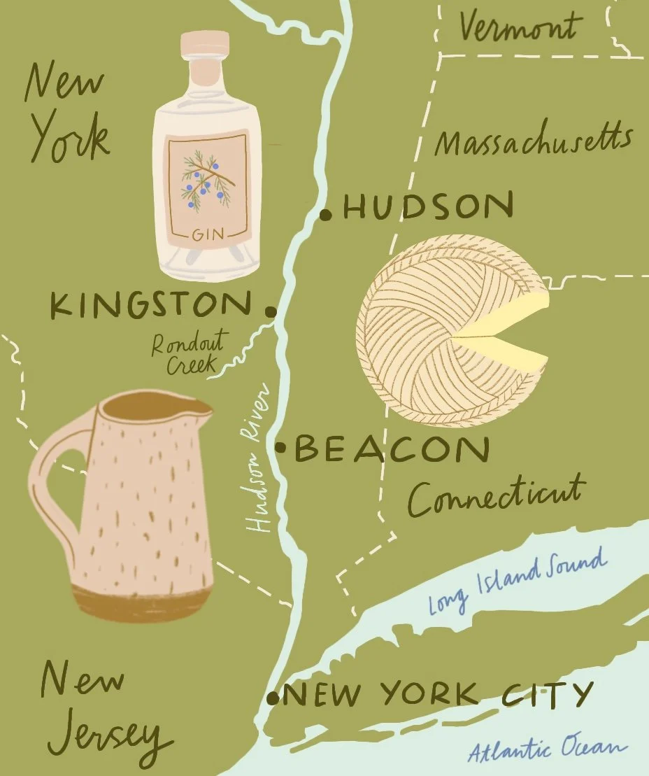
This illustrated map of Hudson Valley Highlights from Beacon to Kingston was commissioned for the Wall Street Journal in August 2022. This map depicts locally made cheese, gin and antiques.
This map of Valle de Guadalupe in Baja California was created by Aly Miller for the Wall Street Journal in a travel story about Mexico’s wine region. Published in June 2022.
I was commissioned to create this illustrated map of the Bronx's Little Italy by Arthur Avenue Food Tours, and it was printed on postcards and a tote bag. Here is the map that I created, along with several of my favorite spot illustrations of cannoli, ravioli, olive oil and more.
It was so meaningful to me to get to know to the small businesses on and around Arthur Avenue as I researched and created this piece. There's nothing better than celebrating small family-run businesses through maps!
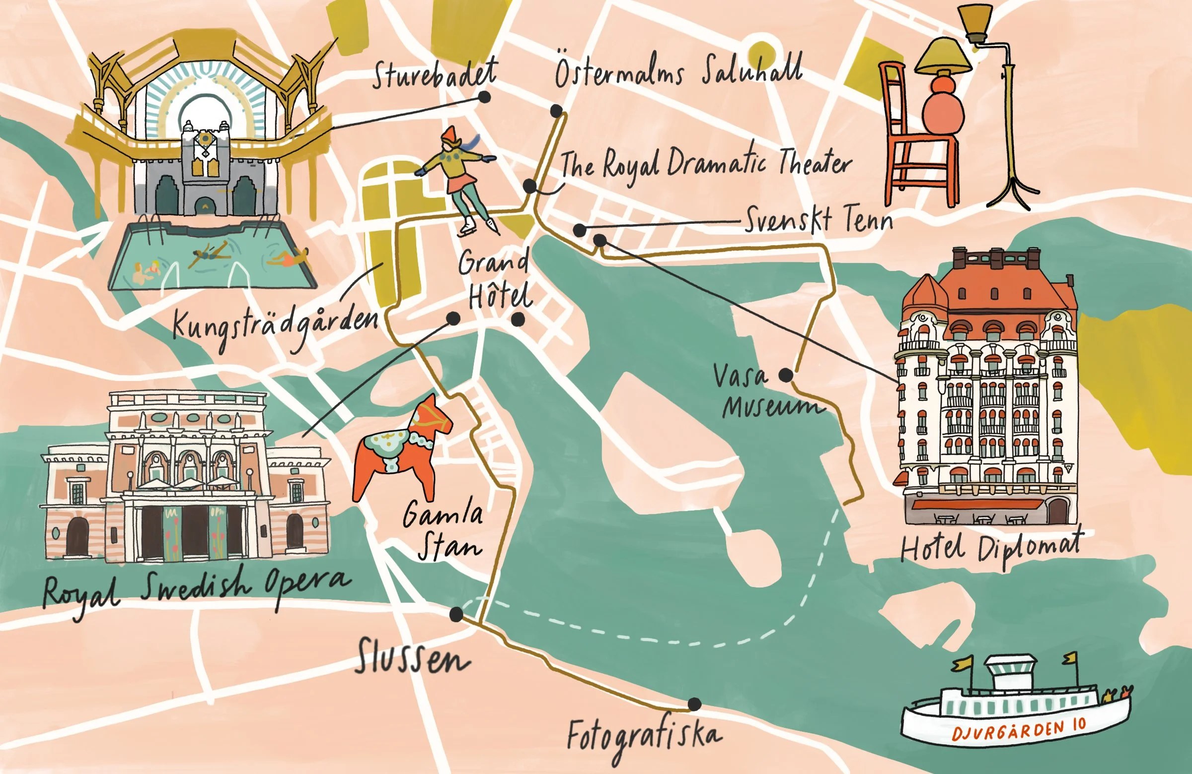
This map was created by Aly Miller for the Wall Street Journal for a story called “In Winter, Stockholm’s Charms Are Many—and the Tourist Crowds Gone” in February 2023.
For the Wall Street Journal: An All-American Road Trip Through Ohio. This map shows destinations throughout Ohio, illustrating regional favorites and architectural standouts.
This map of New York City was commissioned by Tythe Design in 2020, as a love letter to all of the efforts to stay resilient throughout the early days of the pandemic. The title of the map is: “Reasons We Love New York City: Stories of Resiliency During Crisis.”
The map tells the story of New York City as a “resilient city,” which, according to Tythe Designs, “is always evolving to sustain a sense of place and belonging for all residents, ensuring all people can adequately live, work, play, engage, and thrive. In short, a Resilient City promotes a just society.”
You can read more about our process designing this map in this interview we did with the Brooklyn Creative League.
This illustrated map of a roadtrip in Colorado was commissioned by the Wall Street Journal’s Off Duty section in May 2021: Perfect Summer Roadtrip in the Rocky Mountains.
Aly Miller created this illustrated map of Los Angeles for The Nosher, to celebrate LA’s diverse food scene from the Santa Monica Pier and Venice Beach to Downtown LA. The Nosher.com and The Gefilteria commissioned her to make this map to focus on the best spots for Jewish food in LA.
This is an illustrated map of Oakland that highlights Black-owned businesses in North Oakland, created for American Way Magazine.
This illustrated map was created for a wedding weekend in the Catskills for clients who used this as their wedding invitation. Illustrated wedding maps are a great way to welcome your guests and tell your story.
I created this illustrated map for the Zev Team real estate group in Brookline, Massachusetts. For this project, I illustrated small businesses in Brookline to promote these celebrated institutions and the walkability of the neighborhood.
This illustrated map was commissioned by The Wall Street Journal to show popular ice creameries in New Hampshire.
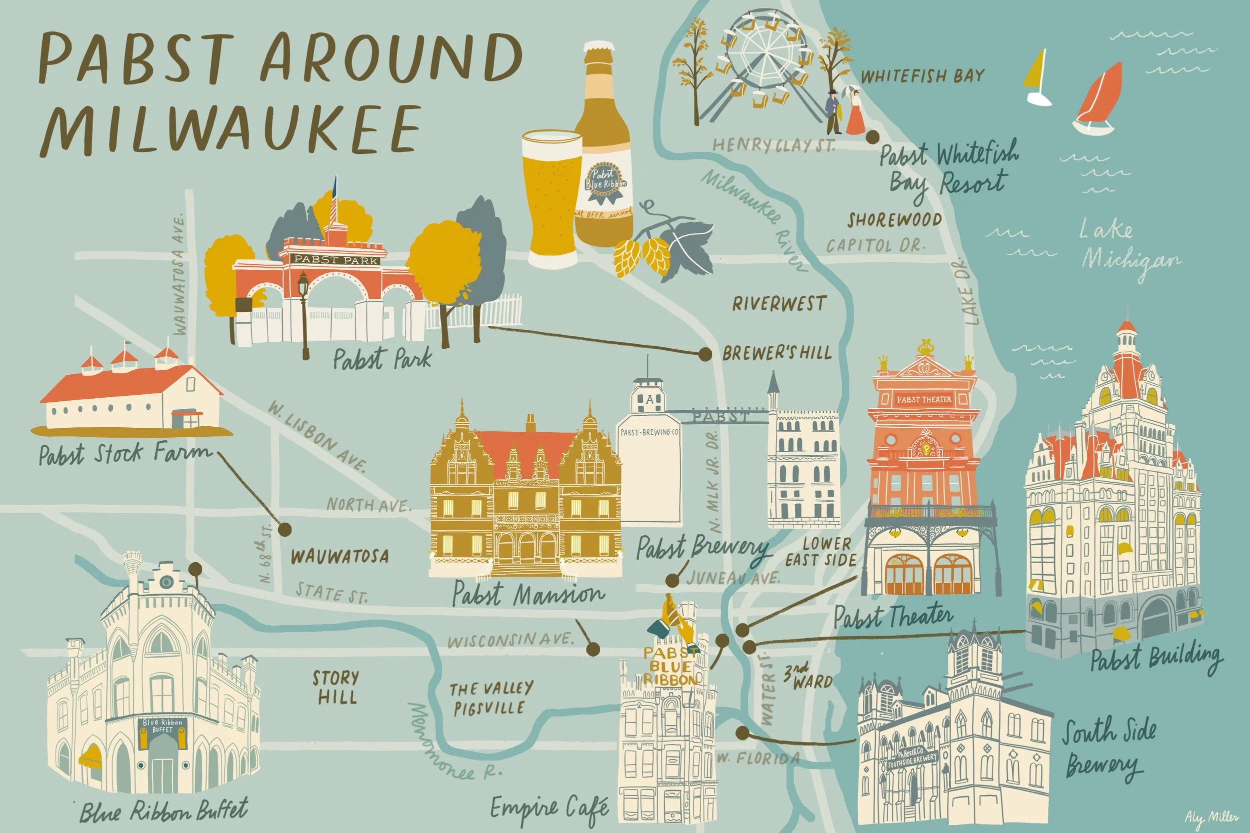
This illustrated map was created for Milwaukee’s Pabst Mansion museum, and is available for sale in their museum gift shop. The news story accompanying this article, Pabst Around Milwaukee: Illustrated Map Details Vast Reach of Frederic Pabst Beyond His Brewery, was published in the Milwaukee Independent.
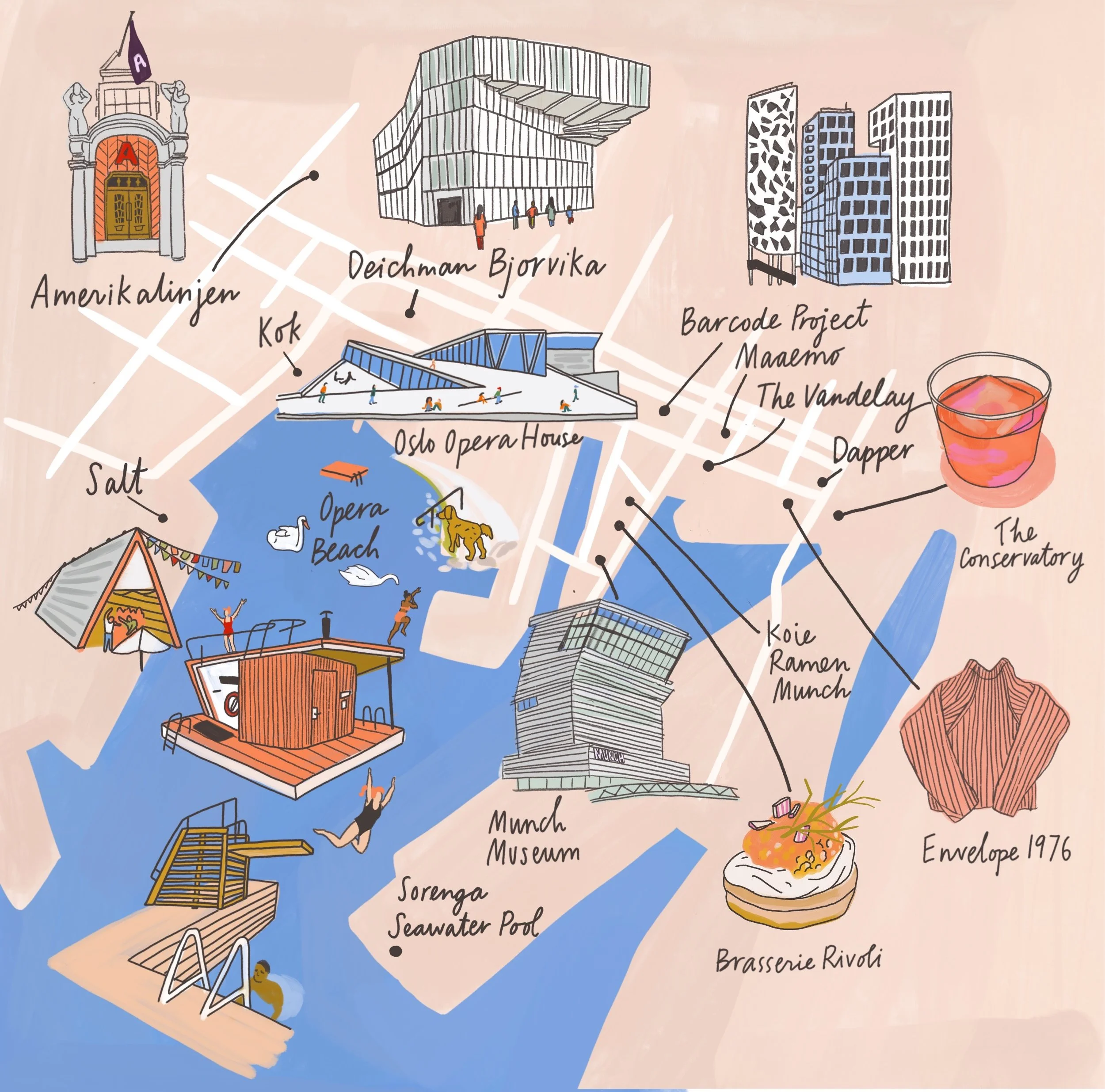
I created this illustrated map of Oslo for the Wall Street Journal Off Duty section, May 2021: The Newest Capitol of Nordic Cool: Oslo. This map highlights the sauna culture, vibrant arts and food scenes to be enjoyed in this Nordic winter wonderland.
I created this illustrated map of Berlin in collaboration with The Nosher and The Gefilteria for an article called The Best Jewish Food in Berlin. This map highlights several of the best places to eat Jewish food in Berlin.